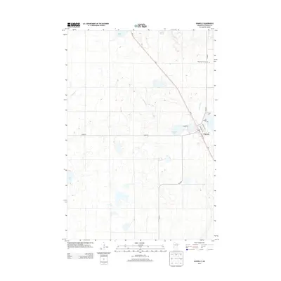
2013 Map of Donnelly
USGS Topo · Published 2013About this map
The prairie village of Donnelly serves as the focal point of this Stevens County survey, situated where MN-9 intersects with local county routes. The town site is structured by streets with international names like Atlantic Ave, Edinburgh Ave, and Balmoral Ave, reflecting a distinct planning style in the heart of the glacial till plains. The landscape is dotted with small prairie lakes and wetlands including Lundberg Lake, Fish Lake, and the meandering Twelvemile Cr. Genealogists will find significant value in the distribution of religious and family-linked burial grounds across the township, including Kongsvringer Lutheran Cem, Vinger Cem, Saint Theresia Cem, and Lundberg Cem. These sites, along with the Post Office in town, anchor the local history of this agricultural community.
Find a feature on this map
17 named features on this map. Tap any name to fly to it.
Don’t see what you’re looking for? This feature index may not catch every label — zoom into the map to look around manually.
Map Details
Editions of this 2013 Donnelly Map
This is the sole edition of this map. No revisions or reprints were ever made.
Other maps of this area
1910 · Chokio
USGS Topo · 1:62,500
1911 · Barrett
USGS Topo · 1:62,500
1911 · Herman
USGS Topo · 1:62,500
1912 · Chokio
USGS Topo · 1:62,500
1912 · Morris
USGS Topo · 1:62,500
1953 · Milbank
USGS Topo · 1:250,000
1953 · Saint Cloud
USGS Topo · 1:250,000
1957 · Saint Cloud
USGS Topo · 1:250,000
1958 · Milbank
USGS Topo · 1:250,000
1958 · Saint Cloud
USGS Topo · 1:250,000