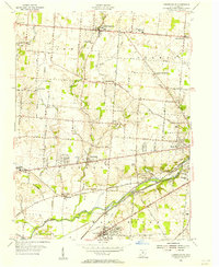
1955 Map of Donnelsville
USGS Topo · Published 1956About this map
Donnelsville sits at the intersection of the National Road and Donnels Creek, serving as a central hub for this agricultural portion of western Ohio in the mid-1950s. The landscape is defined by the broad valley of the Mad River in the south, where the Erie RR and New York Central RR track lines parallel the waterway. Notable social and historical landmarks include the George Rogers Clark State Park and the Clark Co Home for the Aged, reflecting the region's commitment to both public heritage and community welfare. Unique local features such as the Wildason Animal Cem and the prominent Knob Prairie provide distinctive points for genealogical and local history research. Smaller settlements like North Hampton, Lawrenceville, and Enon are connected by a grid of named rural routes, including Ulery Road and Marquart Rd, illustrating the established rural transit network of the era.
Find a feature on this map
61 named features on this map. Tap any name to fly to it.
Don’t see what you’re looking for? This feature index may not catch every label — zoom into the map to look around manually.
Map Details
Editions of this 1955 Donnelsville Map
This is the sole edition of this map. No revisions or reprints were ever made.
Other maps of this area

1904 · Springfield
USGS Topo · 1:62,500

1904 · Dayton
USGS Topo · 1:62,500

1906 · Dayton
USGS Topo · 1:62,500

1906 · Springfield
USGS Topo · 1:62,500

1914 · Troy
USGS Topo · 1:62,500

1914 · St. Paris
USGS Topo · 1:62,500

1916 · St. Paris
USGS Topo · 1:62,500

1944 · St. Paris
USGS Topo · 1:62,500

1944 · Troy
USGS Topo · 1:62,500

1947 · Columbus
USGS Topo · 1:250,000