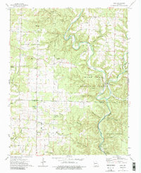
1973 Map of Dora
USGS Topo · Published 1986About this map
The North Fork White River carves a deep path through the southern Ozarks on this 1970s survey, marking the boundary between Douglas and Ozark counties. The landscape is defined by its karst topography and water resources, featuring prominent springs like Hebron Spring and Blue Spring, along with subterranean features such as Turnbull Cave and Bat Cave. Small rural settlements like Dora and Richville anchor the community, while the Mark Twain National Forest encompasses much of the eastern terrain. Genealogy researchers will find numerous family-named landmarks and burial sites, including Pleasant Mound Cem and Innman Cem. The map also captures the recreational character of the river valley, noting the Hammonds Mill Camp and several campgrounds and boat ramps that served visitors to the Rich Land and Spring Creek areas.
Find a feature on this map
58 named features on this map. Tap any name to fly to it.
Don’t see what you’re looking for? This feature index may not catch every label — zoom into the map to look around manually.
Map Details
Editions of this 1973 Dora Map
3 editions found
Other maps of this area

1934 · Gainesville
USGS Topo · 1:48,000

1937 · Buckhart
USGS Topo · 1:48,000

1939 · Topaz
USGS Topo · 1:62,500

1940 · Gainesville
USGS Topo · 1:62,500

1941 · Topaz
USGS Topo · 1:62,500

1943 · Buckhart
USGS Topo · 1:62,500

1944 · Cureall
USGS Topo · 1:62,500

1945 · Harrison
USGS Topo · 1:250,000

1945 · Buckhart
USGS Topo · 1:62,500

1946 · Cureall
USGS Topo · 1:62,500