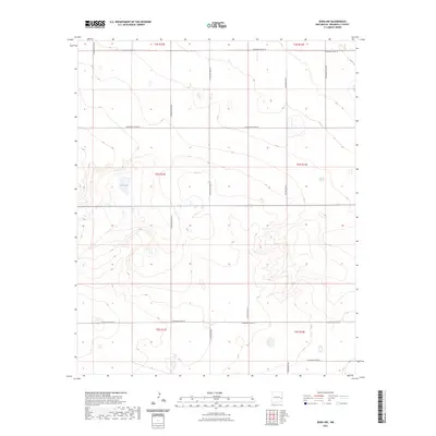
2023 Map of Dora NW
USGS Topo · Published 2023About this map
Red Lake provides a central landmark in this high plains landscape of eastern New Mexico, where the terrain is organized by a precise grid of sectional boundaries and local access roads. This 2023 survey by the U.S. Geological Survey details a rural expanse defined by its transition between townships, including t3s r33e, t4s r33e, and t5s r33e. The road network, including S Roosevelt Road 18 and S Roosevelt Road 20, follows the rigid survey lines characteristic of the American West, indicating a landscape heavily utilized for ranching or dryland agriculture. Without dense settlements, the map focuses on the subtle hydrography and the infrastructure required to navigate this portion of Roosevelt County.
Find a feature on this map
18 named features on this map. Tap any name to fly to it.
Don’t see what you’re looking for? This feature index may not catch every label — zoom into the map to look around manually.
Map Details
Editions of this 2023 Dora NW Map
This is the sole edition of this map. No revisions or reprints were ever made.
Other maps of this area

1954 · Clovis
USGS Topo · 1:250,000

1954 · Brownfield
USGS Topo · 1:250,000

1957 · Portales
USGS Topo · 1:62,500

1958 · Brownfield
USGS Topo · 1:250,000

1958 · Clovis
USGS Topo · 1:250,000

1962 · Brownfield
USGS Topo · 1:250,000

1972 · Dora NW
USGS Topo · 1:24,000

1972 · Dora SW
USGS Topo · 1:24,000
1972 · Pep
USGS Topo · 1:24,000

1972 · Dora
USGS Topo · 1:24,000