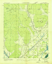
1936 Map of Doran Cove
USGS Topo · Published 1936About this map
Stevenson and the surrounding Jackson County terrain appear here during a transformative era of mid-1930s infrastructure development. The Tennessee River is documented prior to the completion of major TVA projects, featuring the Widows Bar Lock and Dam and the U S Lock. The landscape is a network of industrial and rural sites, from the Montague Mines and Baugh Mine on the slopes of the Cumberland Plateau to the local centers of Cumberland Junction and Mt Carmel.
Find a feature on this map
65 named features on this map. Tap any name to fly to it.
Don’t see what you’re looking for? This feature index may not catch every label — zoom into the map to look around manually.
Map Details
Editions of this 1936 Doran Cove Map
This is the sole edition of this map. No revisions or reprints were ever made.
Other maps of this area

1886 · Stevenson
USGS Topo · 1:125,000

1892 · Stevenson
USGS Topo · 1:125,000

1895 · Stevenson
USGS Topo · 1:125,000

1895 · Sewanee
USGS Topo · 1:125,000

1936 · Orme
USGS Topo · 1:24,000

1936 · Bridgeport
USGS Topo · 1:24,000

1936 · Wannville
USGS Topo · 1:24,000

1936 · Flat Rock
USGS Topo · 1:24,000

1936 · Sinking Cove
USGS Topo · 1:24,000

1936 · Stevenson
USGS Topo · 1:24,000