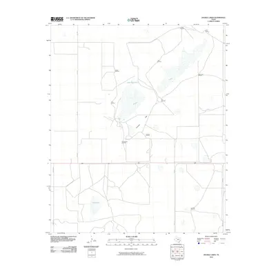
2010 Map of Double Lakes
USGS Topo · Published 2010About this map
Double Lakes and Twin Lakes dominate this portion of the Texas South Plains, reflecting the vital role of ephemeral water sources in Lynn County’s ranching landscape. The terrain is defined by wide expanses such as Antelope Flats, where the distribution of water was historically managed through a network of strategically placed windmills. These named landmarks, including Eureka Windmill, Crows Nest Windmill, and HorsePasture Windmill, are essential markers for tracing property lines and grazing patterns of the early 21st century. The northern corner of the quadrangle is occupied by the T Bar Ranch, a significant local landholding. While rural roads like FM 1328 and FM 3112 provide a modern transportation framework, the map primarily captures the persistence of the ranching economy, where features like Stud Duck Tank and Little Gyp Windmill serve as the primary geographical anchors for residents and land managers.
Find a feature on this map
18 named features on this map. Tap any name to fly to it.
Don’t see what you’re looking for? This feature index may not catch every label — zoom into the map to look around manually.
Map Details
Editions of this 2010 Double Lakes Map
This is the sole edition of this map. No revisions or reprints were ever made.
Other maps of this area

1954 · Lubbock
USGS Topo · 1:250,000

1954 · Brownfield
USGS Topo · 1:250,000

1957 · New Home
USGS Topo · 1:62,500

1957 · Meadow
USGS Topo · 1:62,500

1958 · Brownfield
USGS Topo · 1:250,000

1962 · Brownfield
USGS Topo · 1:250,000

1969 · Mound Lake
USGS Topo · 1:24,000

1969 · Skeen Lake
USGS Topo · 1:24,000

1969 · New Moore
USGS Topo · 1:24,000

1969 · Tahoka
USGS Topo · 1:24,000