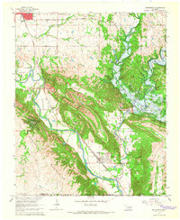
1965 Map of Dougherty
USGS Topo · Published 1966About this map
The Arbuckle Mountains dominate this 1960s landscape, where the Washita River carves through narrow gaps between limestone ridges. A significant transformation is underway at the Arbuckle Reservoir, where the Arbuckle Dam (Under Constr) is shown in progress, marking the transition from a riverine valley to a managed water resource. The industrial character of the era is evident through the numerous quarries and gravel pits that pockmark the terrain near Dougherty, a town defined by its proximity to the Atchison Topeka and Santa Fe Railroad Grade.
Find a feature on this map
38 named features on this map. Tap any name to fly to it.
Don’t see what you’re looking for? This feature index may not catch every label — zoom into the map to look around manually.
Map Details
Editions of this 1965 Dougherty Map
3 editions found
Other maps of this area

1898 · Pauls Valley
USGS Topo · 1:125,000

1901 · Stonewall
USGS Topo · 1:125,000

1901 · Tishomingo
USGS Topo · 1:125,000

1901 · Ardmore
USGS Topo · 1:125,000

1902 · Pauls Valley
USGS Topo · 1:125,000

1918 · Ardmore
USGS Topo · 1:125,000

1957 · Ardmore
USGS Topo · 1:250,000

1963 · Ardmore
USGS Topo · 1:250,000

1963 · Sulphur South
USGS Topo · 1:24,000

1963 · Nebo
USGS Topo · 1:24,000