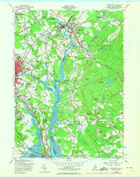
1956 Map of Dover East
USGS Topo · Published 1974About this map
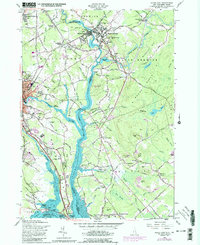
Salmon Falls River and the Piscataqua River define the winding border between Maine and New Hampshire in this mid-century survey of the Dover and South Berwick area. The landscape is a network of river-driven industrial heritage and early rail transit, evidenced by the Boston and Maine Railroad routes connecting Rollinsford Station and Agamenticus Station. Notable educational and religious landmarks like the Berwick Academy and numerous burial grounds, including St Patricks Cem and St Michaels Cem, are clearly marked across the hills. The terrain is characterized by named elevations such as Indigo Hill and Powderhouse Hill, while the tidal flats of the Piscataqua River and Pomeroy Cove illustrate the coastal influence on this inland corridor. This map also tracks the introduction of the Spaulding Turnpike, signaling the transition from local rural roads like Sligo Road to modern regional highway systems.
Find a feature on this map
98 named features on this map. Tap any name to fly to it.
Don’t see what you’re looking for? This feature index may not catch every label — zoom into the map to look around manually.
Map Details
Editions of this 1956 Dover East Map
5 editions found
Other maps of this area

1891 · Berwick
USGS Topo · 1:62,500

1891 · Kennebunk
USGS Topo · 1:62,500

1893 · Kennebunk
USGS Topo · 1:62,500

1893 · Dover
USGS Topo · 1:62,500

1893 · Berwick
USGS Topo · 1:62,500

1893 · York
USGS Topo · 1:62,500

1898 · Kennebunk
USGS Topo · 1:62,500

1916 · Dover
USGS Topo · 1:62,500

1918 · Dover
USGS Topo · 1:62,500

1920 · York
USGS Topo · 1:62,500