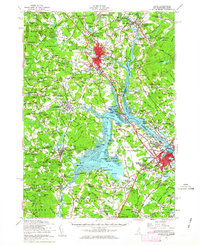
1956 Map of Dover
USGS Topo · Published 1963About this map
The Piscataqua River and its complex tidal tributaries anchor this mid-century look at the Seacoast region, showing the area as it stood after the establishment of Pease Air Force Base. The transition from rural farming to Cold War-era infrastructure is evident in the development of Atlantic Heights and Pannaway Manor near Portsmouth, contrasted with the academic grounds of the University of New Hampshire in Durham.
Find a feature on this map
141 named features on this map. Tap any name to fly to it.
Don’t see what you’re looking for? This feature index may not catch every label — zoom into the map to look around manually.
Map Details
Editions of this 1956 Dover Map
4 editions found

Other maps of this area

1888 · Newburyport
USGS Topo · 1:62,500

1888 · Haverhill
USGS Topo · 1:62,500

1890 · Haverhill
USGS Topo · 1:62,500

1890 · Newburyport
USGS Topo · 1:62,500

1891 · Berwick
USGS Topo · 1:62,500

1891 · Kennebunk
USGS Topo · 1:62,500

1893 · Kennebunk
USGS Topo · 1:62,500

1893 · Dover
USGS Topo · 1:62,500

1893 · Berwick
USGS Topo · 1:62,500

1893 · York
USGS Topo · 1:62,500