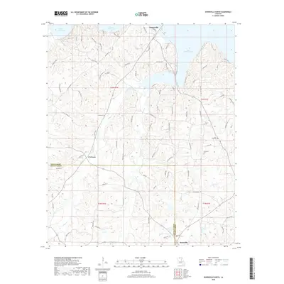
2018 Map of Downsville North
USGS Topo · Published 2018About this map
Bayou D'Arbonne Lake dominates the northern reaches of this landscape, its fingers reaching into the surrounding piney hills of North Louisiana. The boundary between Union and Lincoln Parishes bisects the map, framing a region where rural life is anchored by family-named landmarks and historical burial grounds. Small communities like Downsville and Farmerville serve as local hubs, connected by a network of winding roads such as Prentice Gibson Rd and Hicks Frazier Rd. The terrain is defined by the drainage systems of Stowe Creek and Cypress Cr, which carve through the undulating topography. Genealogists will find particular value in the numerous documented cemeteries, including Sardis Cem and Feazel Cem, which mark the presence of established families across several townships.
Find a feature on this map
89 named features on this map. Tap any name to fly to it.
Don’t see what you’re looking for? This feature index may not catch every label — zoom into the map to look around manually.
Map Details
Editions of this 2018 Downsville North Map
This is the sole edition of this map. No revisions or reprints were ever made.
Other maps of this area

1950 · Ruston
USGS Topo · 1:62,500

1951 · Ruston
USGS Topo · 1:62,500

1951 · Bernice
USGS Topo · 1:62,500

1952 · Calhoun
USGS Topo · 1:62,500

1952 · Farmerville
USGS Topo · 1:62,500

1955 · Shreveport
USGS Topo · 1:250,000

1956 · Shreveport
USGS Topo · 1:250,000
1982 · Calhoun
USGS Topo · 1:24,000
1982 · Point
USGS Topo · 1:24,000
1982 · Downsville North
USGS Topo · 1:24,000