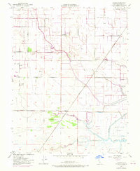
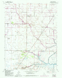
1952 Map of Dozier
USGS Topo · Published 1970About this map
Sacramento Northern rail lines cut across this agricultural and wetland landscape in Solano County, connecting remote whistle-stops and siding settlements during the mid-20th century. The map highlights the transition from terrestrial farming to the complex waterway network of the California Delta, anchored by the Hastings Tract. Notable early local infrastructure is visible, including the Maine Prairie School and the nearby Maine Prairie (Site), indicating the shift of settlement patterns over time. The drainage and transport economy of the region is clearly defined by engineered waterways such as Calhoun Cut, The Big Ditch, and Lindsey Slough. Small agricultural hubs like Binghamton, Dozier, and Bunker are situated along the rail and road corridors, while the presence of a Naval Reservation and Military Res reflects the strategic importance of the area's geography.
Find a feature on this map
19 named features on this map. Tap any name to fly to it.
Don’t see what you’re looking for? This feature index may not catch every label — zoom into the map to look around manually.
Map Details
Editions of this 1952 Dozier Map
5 editions found
Other maps of this area

1907 · Antioch
USGS Topo · 1:62,500

1908 · Vacaville
USGS Topo · 1:62,500

1908 · Courtland
USGS Topo · 1:62,500

1908 · Antioch
USGS Topo · 1:62,500

1910 · Rio Vista
USGS Topo · 1:31,680

1916 · Dixon
USGS Topo · 1:31,680

1916 · Cache Slough
USGS Topo · 1:31,680

1916 · Maine Prairie
USGS Topo · 1:31,680
1916 · Saxon
USGS Topo · 1:31,680

1917 · Wolfskill
USGS Topo · 1:31,680