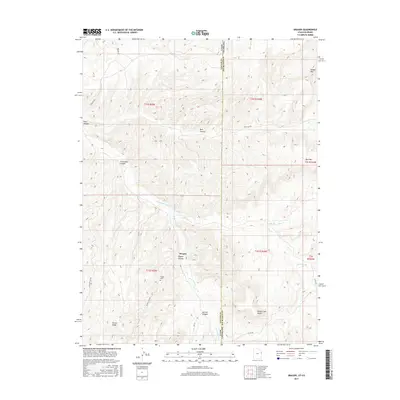
2017 Map of Dragon
USGS Topo · Published 2017About this map
Dragon sits at the heart of this high-elevation landscape on the border of Utah and Colorado, where the arid topography is defined by deep incisions like Park Canyon and Dragon Canyon. The settlement is closely tied to its environment, situated near the headwaters of Evacuation Creek and Missouri Cr. This 2017 survey reveals a region dominated by relief features, including the prominent White Face Butte to the southeast and the looming profile of Rabbit Mtn on the northeastern state line. Genealogists and local historians can locate the Dragon Cem positioned north of the townsite, a quiet waypoint along Dragon Canyon Rd. The map also traces the winding courses of Texas Cr and various ridgelines such as Rector Ridge, providing a detailed look at the corridor connecting Uintah County to Rio Blanco County.
Find a feature on this map
26 named features on this map. Tap any name to fly to it.
Don’t see what you’re looking for? This feature index may not catch every label — zoom into the map to look around manually.
Map Details
Editions of this 2017 Dragon Map
This is the sole edition of this map. No revisions or reprints were ever made.
Other maps of this area

1885 · East Tavaputs
USGS Topo · 1:250,000

1956 · Grand Junction
USGS Topo · 1:250,000

1959 · Grand Junction
USGS Topo · 1:250,000

1960 · Grand Junction
USGS Topo · 1:250,000

1962 · Grand Junction
USGS Topo · 1:250,000

1964 · Grand Junction
USGS Topo · 1:250,000

1964 · Texas Creek
USGS Topo · 1:24,000

1964 · East Evacuation Creek
USGS Topo · 1:24,000
1964 · Banta Ridge
USGS Topo · 1:24,000

1965 · Grand Junction
USGS Topo · 1:250,000