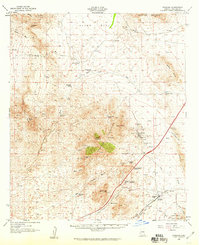
1958 Map of Dragoon
USGS Topo · Published 1959About this map
Dragoon sits at the southern edge of this survey, serving as a vital rail point where the Southern Pacific tracks thread through the gap between the Little Dragoon Mountains and the Gunnison Hills. The landscape is defined by its deep mining heritage, particularly around the settlement of Johnson, which is surrounded by the Republic Mine, OK Mine, and Keystone Mine. This mid-century record captures the ranching and mining economy of Cochise County just as industrial patterns were shifting. Scattered across the arid terrain are numerous family-named holdings such as Seven Dash Ranch, Triangle T Ranch, and Walker Ranch. Notable landmarks include the Airway Beacon atop Adams Peak and the Tungsten King Mine tucked into Clark Canyon, illustrating the varied uses of the high desert terrain from transportation and aviation to hard-rock extraction.
Find a feature on this map
58 named features on this map. Tap any name to fly to it.
Don’t see what you’re looking for? This feature index may not catch every label — zoom into the map to look around manually.
Map Details
Editions of this 1958 Dragoon Map
3 editions found
Other maps of this area

1915 · Benson
USGS Topo · 1:125,000

1916 · Pearce
USGS Topo · 1:125,000

1922 · Willcox
USGS Topo · 1:125,000

1922 · St. David
USGS Topo · 1:62,500

1926 · Whetstone
USGS Topo · 1:62,500

1926 · Courtland
USGS Topo · 1:62,500

1943 · Willcox
USGS Topo · 1:62,500

1943 · Benson
USGS Topo · 1:125,000

1943 · Cochise
USGS Topo · 1:62,500

1943 · Dragoon
USGS Topo · 1:62,500