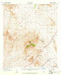
1958 Map of Dragoon
USGS Topo · Published 1961About this map
Little Dragoon Mountains dominate this landscape, serving as a hub for both industrial activity and ranching life in Cochise County. The mining settlement of Johnson is a focal point of the era, surrounded by numerous claims including the Republic Mine, OK Mine, and Keystone Mine. This concentration of extraction points, coupled with a Cemetery and various prospects, illustrates the intense mineral exploration centered near Johnson Peak. To the south, the Southern Pacific railroad cuts through Dragoon Pass, anchoring the town of Dragoon and providing a vital transit link across the basin.
Find a feature on this map
66 named features on this map. Tap any name to fly to it.
Don’t see what you’re looking for? This feature index may not catch every label — zoom into the map to look around manually.
Map Details
Editions of this 1958 Dragoon Map
3 editions found
Other maps of this area

1915 · Benson
USGS Topo · 1:125,000

1916 · Pearce
USGS Topo · 1:125,000

1922 · Willcox
USGS Topo · 1:125,000

1922 · St. David
USGS Topo · 1:62,500

1926 · Whetstone
USGS Topo · 1:62,500

1926 · Courtland
USGS Topo · 1:62,500

1943 · Willcox
USGS Topo · 1:62,500

1943 · Benson
USGS Topo · 1:125,000

1943 · Cochise
USGS Topo · 1:62,500

1943 · Dragoon
USGS Topo · 1:62,500