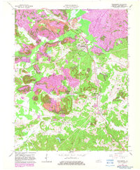
1963 Map of Drakesboro
USGS Topo · Published 1983About this map
Drakesboro and its surrounding coal communities reflect an era of intensive extraction and transport in Muhlenberg County. The landscape is defined by extensive Strip Mines and the infrastructure required to support them, including a notable Tipple near Browder and several Mines scattered throughout the hills. Rail traffic is the backbone of this district, with the Louisville and Nashville and Illinois Central railroads navigating the terrain. Unique engineering features such as the Twin Tunnels and a single Tunnel to the south demonstrate the complexity of moving coal through this corrugated topography.
Find a feature on this map
43 named features on this map. Tap any name to fly to it.
Don’t see what you’re looking for? This feature index may not catch every label — zoom into the map to look around manually.
Map Details
Editions of this 1963 Drakesboro Map
3 editions found
Other maps of this area

1909 · Hartford
USGS Topo · 1:62,500

1909 · Central City
USGS Topo · 1:62,500

1911 · Drakesboro
USGS Topo · 1:48,000

1911 · Dunmor
USGS Topo · 1:48,000

1913 · Drakesboro
USGS Topo · 1:62,500

1914 · Dunmor
USGS Topo · 1:62,500

1952 · Greenville
USGS Topo · 1:24,000

1953 · Drakesboro
USGS Topo · 1:24,000

1953 · Rosewood
USGS Topo · 1:24,000

1953 · Central City West
USGS Topo · 1:24,000