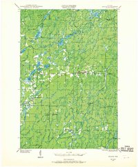
1944 Map of Draper
USGS Topo · Published 1970About this map
Loretta and Draper serve as the primary focal points of this 1944 survey, situated within the dense woodlands of the Chequamegon National Forest. The landscape is defined by the East Fork Chippewa River and the Chicago St Paul Minneapolis and Omaha Railway, which cuts across the central portion of the map alongside State Highway No 70. This era of Sawyer County history is characterized by its legacy of logging and forestry, evidenced by numerous named encampments such as Old Le May Camp and Old Koshack Camp scattered throughout the wetlands. Several surveillance points, including the Black Lake Fire Tower and the Site of Old Draper Tower, reflect the critical importance of fire management in this heavily timbered region. Local community life is marked by rural institutions like the Loretta Sch and the Loretta Cem.
Find a feature on this map
52 named features on this map. Tap any name to fly to it.
Don’t see what you’re looking for? This feature index may not catch every label — zoom into the map to look around manually.
Map Details
Editions of this 1944 Draper Map
2 editions found
Other maps of this area

1941 · Kennan
USGS Topo · 1:48,000

1941 · Kennedy
USGS Topo · 1:48,000

1942 · Glidden
USGS Topo · 1:48,000

1942 · Clam Lake
USGS Topo · 1:48,000

1943 · Namekagon Lake
USGS Topo · 1:48,000

1944 · Exeland
USGS Topo · 1:48,000

1944 · Draper
USGS Topo · 1:48,000

1944 · Radisson
USGS Topo · 1:48,000

1945 · Kennedy
USGS Topo · 1:48,000

1945 · Namekagon Lake
USGS Topo · 1:48,000