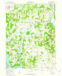
1962 Map of Dresden
USGS Topo · Published 1963About this map
Wakatomika Creek and the Muskingum River converge near the town of Dresden, where the Pennsylvania and New York Central railroads highlight the area's mid-century industrial footprint. The landscape transitions from the river valley to the heights of The Highlands, punctuated by numerous rural institutions like Muskingum Ch, St Marys Ch, and Sherrods Chapel (Meth).
Find a feature on this map
47 named features on this map. Tap any name to fly to it.
Don’t see what you’re looking for? This feature index may not catch every label — zoom into the map to look around manually.
Map Details
Editions of this 1962 Dresden Map
4 editions found
Other maps of this area

1908 · Conesville
USGS Topo · 1:62,500

1910 · Frazeysburg
USGS Topo · 1:62,500

1910 · Philo
USGS Topo · 1:62,500

1910 · Zanesville
USGS Topo · 1:62,500

1910 · Conesville
USGS Topo · 1:62,500

1947 · Columbus
USGS Topo · 1:250,000

1949 · Clarksburg
USGS Topo · 1:250,000

1950 · Marion
USGS Topo · 1:250,000

1951 · Canton
USGS Topo · 1:250,000

1953 · Canton
USGS Topo · 1:250,000