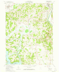
1962 Map of Dresden
USGS Topo · Published 1973About this map
Frazeysburg and Dresden anchor the northern reaches of this Muskingum County landscape during the early 1960s, a period when the regional infrastructure supported both agricultural and industrial interests. The eastern edge is defined by the Muskingum River, where the New York Chicago and St Louis railroad parallels the water, while the Pennsylvania line cuts through the northwest corner. A network of country churches and family burial grounds, including St Marys Ch, Covenanter Cem, and Bethlehem Cem, are scattered across the interior highlands.
Find a feature on this map
42 named features on this map. Tap any name to fly to it.
Don’t see what you’re looking for? This feature index may not catch every label — zoom into the map to look around manually.
Map Details
Editions of this 1962 Dresden Map
4 editions found
Other maps of this area

1908 · Conesville
USGS Topo · 1:62,500

1910 · Frazeysburg
USGS Topo · 1:62,500

1910 · Philo
USGS Topo · 1:62,500

1910 · Zanesville
USGS Topo · 1:62,500

1910 · Conesville
USGS Topo · 1:62,500

1947 · Columbus
USGS Topo · 1:250,000

1949 · Clarksburg
USGS Topo · 1:250,000

1950 · Marion
USGS Topo · 1:250,000

1951 · Canton
USGS Topo · 1:250,000

1953 · Canton
USGS Topo · 1:250,000