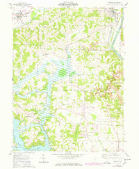
1962 Map of Dresden
USGS Topo · Published 1978About this map
Wakatomika Creek and the Muskingum River define the local topography of this section of Muskingum County, where the transition from agriculture to heavy industry is visible through extensive strip mine operations. Near the community of Dresden, the landscape is marked by the convergence of the Pennsylvania and New York Central railroads, highlighting the area's history as a transportation corridor. The southern portion of the map reveals the waters of Dillon Lake and the engineering of the Pleasant Valley Dike. Genealogists will find a high density of rural landmarks, including Muskingum Ch, St Marys Ch, and numerous family burial grounds such as Garinger Cem and Baxter Cem. These features, alongside Nashport Sch and Parr Airfield, illustrate the distributed nature of mid-century rural Ohio settlements.
Find a feature on this map
46 named features on this map. Tap any name to fly to it.
Don’t see what you’re looking for? This feature index may not catch every label — zoom into the map to look around manually.
Map Details
Editions of this 1962 Dresden Map
4 editions found
Other maps of this area

1908 · Conesville
USGS Topo · 1:62,500

1910 · Frazeysburg
USGS Topo · 1:62,500

1910 · Philo
USGS Topo · 1:62,500

1910 · Zanesville
USGS Topo · 1:62,500

1910 · Conesville
USGS Topo · 1:62,500

1947 · Columbus
USGS Topo · 1:250,000

1949 · Clarksburg
USGS Topo · 1:250,000

1950 · Marion
USGS Topo · 1:250,000

1951 · Canton
USGS Topo · 1:250,000

1953 · Canton
USGS Topo · 1:250,000