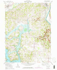
1962 Map of Dresden
USGS Topo · Published 1978About this map
The Muskingum River defines the eastern edge of this landscape, where the New York Central and Chicago and Pennsylvania railroads converge at Dresden. To the south, the creation of Dillon Lake has fundamentally altered the terrain, necessitating the Pleasant Valley Dike and submerging former valley floors. This 1960s-era geography, updated with late-1970s revisions, shows a rural district transitioning with the times, featuring infrastructure like the Waterworks and Parr Airfield alongside traditional landmarks.
Find a feature on this map
45 named features on this map. Tap any name to fly to it.
Don’t see what you’re looking for? This feature index may not catch every label — zoom into the map to look around manually.
Map Details
Editions of this 1962 Dresden Map
4 editions found
Other maps of this area

1908 · Conesville
USGS Topo · 1:62,500

1910 · Frazeysburg
USGS Topo · 1:62,500

1910 · Philo
USGS Topo · 1:62,500

1910 · Zanesville
USGS Topo · 1:62,500

1910 · Conesville
USGS Topo · 1:62,500

1947 · Columbus
USGS Topo · 1:250,000

1949 · Clarksburg
USGS Topo · 1:250,000

1950 · Marion
USGS Topo · 1:250,000

1951 · Canton
USGS Topo · 1:250,000

1953 · Canton
USGS Topo · 1:250,000