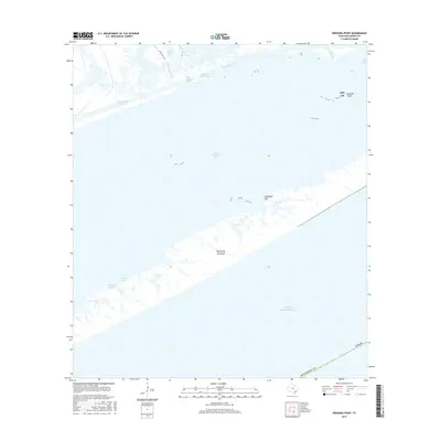
2016 Map of Dressing Point
USGS Topo · Published 2016About this map
East Matagorda Bay and the narrow barrier of the Matagorda Peninsula dominate this coastal landscape. The transition from the protected waters of the bay to the open Gulf of Mexico is defined by tidal flats and complex aquatic networks, including the Intracoastal Waterway which facilitates marine traffic through the region. Land-based features are few in this maritime environment, primarily consisting of the Bbn Wr wildlife refuge and isolated points of interest such as Dressing Point and Eidelbach Flat. Drainage from the mainland is captured by Live Oak Bayou and Cleveland Bayou, while Bear Ranch Rd provides the only significant land route toward the marshy northern shore near Boggy Lake. The map illustrates the fragile coastal geography of Matagorda County as it appeared in 2016.
Find a feature on this map
16 named features on this map. Tap any name to fly to it.
Don’t see what you’re looking for? This feature index may not catch every label — zoom into the map to look around manually.
Map Details
Editions of this 2016 Dressing Point Map
This is the sole edition of this map. No revisions or reprints were ever made.
Other maps of this area

1951 · Bay City
USGS Topo · 1:250,000

1952 · Lake Austin
USGS Topo · 1:24,000

1952 · Matagorda
USGS Topo · 1:24,000

1952 · Dressing Point
USGS Topo · 1:24,000
1952 · Matagorda SW
USGS Topo · 1:24,000
1952 · Brown Cedar Cut
USGS Topo · 1:24,000

1952 · Sargent
USGS Topo · 1:24,000

1952 · Wadsworth
USGS Topo · 1:24,000

1956 · Bay City
USGS Topo · 1:250,000

1958 · Bay City
USGS Topo · 1:250,000