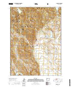
2020 Map of Drews Gap
USGS Topo · Published 2020About this map
The Fremont National Forest dominates this high-altitude landscape of southern Lake County, Oregon, where the terrain transitions through a series of significant mountain passes and water management systems. The strategic Drews Gap and the neighboring Drews Gap Summit mark the primary passage through the hills, followed closely by the descent into Antelope Canyon. This area is defined by its complex irrigation and water storage network, supporting the high desert cattle and timber economy. Named reservoirs such as Junipers Reservoir, Clyde Fenimore Reservoir, and the Willow Cr Reservoir are interspersed with natural features like Patton Meadow and Fish Lake. A distinct system of man-made waterways including the Number Six Canal, N Canal, and E Canal underscores the critical role of water diversion for the local rangelands.
Find a feature on this map
41 named features on this map. Tap any name to fly to it.
Don’t see what you’re looking for? This feature index may not catch every label — zoom into the map to look around manually.
Map Details
Editions of this 2020 Drews Gap Map
This is the sole edition of this map. No revisions or reprints were ever made.
Other maps of this area

1955 · Klamath Falls
USGS Topo · 1:250,000

1958 · Klamath Falls
USGS Topo · 1:250,000

1964 · Drews Reservoir
USGS Topo · 1:24,000

1964 · Lakeview SW
USGS Topo · 1:24,000

1964 · Cox Flat
USGS Topo · 1:24,000

1964 · Lakeview NW
USGS Topo · 1:24,000
1964 · Dog Lake
USGS Topo · 1:24,000

1964 · Cougar Peak
USGS Topo · 1:24,000
1964 · Fitzwater Point
USGS Topo · 1:24,000

1964 · Drews Gap
USGS Topo · 1:24,000