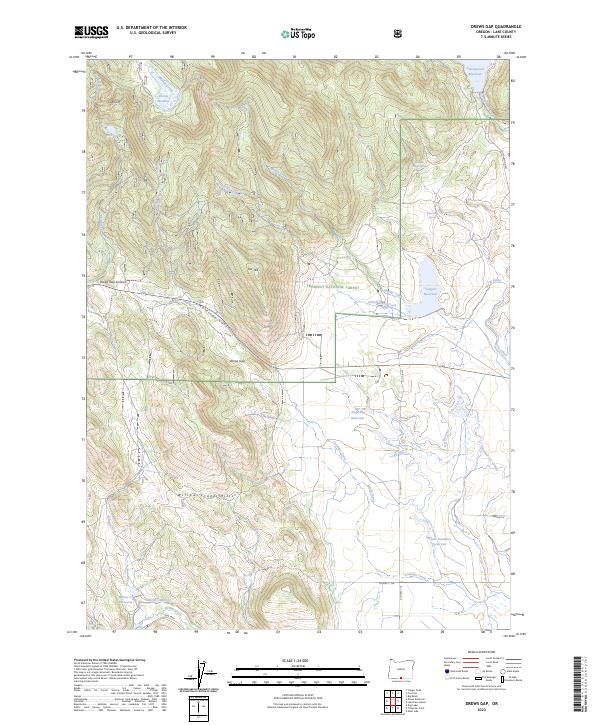
2023 Map of Drews Gap
USGS Topo · Published 2023About this map
Fremont National Forest dominates the northern reaches of this high-altitude landscape, where the terrain transitions from the volcanic heights of Cub Cliff and Drews Gap Summit into a complex network of water management. The map reveals an intricate irrigation and drainage system critical to the region's ranching and agricultural history, including the North Canal and the Number Six Canal. Several high-country water sources such as White Rock Spring and Wooden Trough Spring are identified alongside larger impoundments like Junipers Reservoir and Clyde Fenimore Reservoir. The high pass at Drews Gap serves as a primary transit point through the Willow Creek Hills, illustrating how the physical geography of Lake County dictates the movement of people and resources between the basins and timberlands.
Find a feature on this map
38 named features on this map. Tap any name to fly to it.
Don’t see what you’re looking for? This feature index may not catch every label — zoom into the map to look around manually.
Map Details
Editions of this 2023 Drews Gap Map
This is the sole edition of this map. No revisions or reprints were ever made.
Other maps of this area

1955 · Klamath Falls
USGS Topo · 1:250,000

1958 · Klamath Falls
USGS Topo · 1:250,000

1964 · Drews Reservoir
USGS Topo · 1:24,000

1964 · Lakeview SW
USGS Topo · 1:24,000

1964 · Cox Flat
USGS Topo · 1:24,000

1964 · Lakeview NW
USGS Topo · 1:24,000
1964 · Dog Lake
USGS Topo · 1:24,000

1964 · Cougar Peak
USGS Topo · 1:24,000
1964 · Fitzwater Point
USGS Topo · 1:24,000

1964 · Drews Gap
USGS Topo · 1:24,000