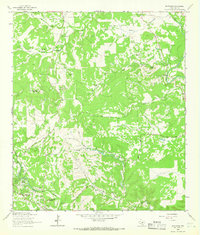
1964 Map of Driftwood
USGS Topo · Published 1966About this map
The community of Wimberley and the upper reaches of Cypress Creek anchor the southern portion of this mid-1960s study in Hays Co. The landscape is defined by the recurring theme of "Lone Man" and "Lone Woman" features, including Lone Man Mountain, Lone Woman Mountain, and the winding Lone Man Creek. These names reflect a local nomenclature tied to the prominent limestone uplifts of the Texas Hill Country, such as Old Baldy and the Little Twin Sister Peaks.
Find a feature on this map
33 named features on this map. Tap any name to fly to it.
Don’t see what you’re looking for? This feature index may not catch every label — zoom into the map to look around manually.
Map Details
Editions of this 1964 Driftwood Map
Other maps of this area

1887 · Blanco
USGS Topo · 1:125,000

1894 · Blanco
USGS Topo · 1:125,000

1896 · Austin
USGS Topo · 1:125,000

1897 · Austin
USGS Topo · 1:125,000

1910 · Austin
USGS Topo · 1:125,000

1911 · San Marcos
USGS Topo · 1:125,000

1919 · San Marcos
USGS Topo · 1:125,000

1929 · Hunter
USGS Topo · 1:62,500

1953 · Seguin
USGS Topo · 1:250,000

1954 · Llano
USGS Topo · 1:250,000