
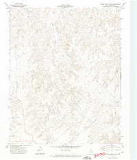
1971 Map of Dry Creek NE
USGS Topo · Published 1974About this map
The Canadian River carves a wide path through this Roberts County landscape, creating a stark division between the dissected plateau to the south and the drainage basins to the north. In the early 1970s, this area of the Texas Panhandle remained largely open ranchland, defined by ephemeral waterways like Sourdough Creek and Picketts Ranch Creek. The map documents the early infrastructure of the regional energy industry, noting an Oil Well and a prominent Pipeline corridor cutting across the terrain.
Find a feature on this map
13 named features on this map. Tap any name to fly to it.
Don’t see what you’re looking for? This feature index may not catch every label — zoom into the map to look around manually.
Map Details
Editions of this 1971 Dry Creek NE Map
This is the sole edition of this map. No revisions or reprints were ever made.
Other maps of this area

1954 · Perryton
USGS Topo · 1:250,000

1954 · Amarillo
USGS Topo · 1:250,000

1958 · Perryton
USGS Topo · 1:250,000

1958 · Amarillo
USGS Topo · 1:250,000

1971 · Dry Creek South
USGS Topo · 1:24,000

1971 · Dry Creek SE
USGS Topo · 1:24,000

1971 · Dry Creek North
USGS Topo · 1:24,000

1972 · Horse Creek North
USGS Topo · 1:24,000
1972 · Horse Creek South
USGS Topo · 1:24,000

1973 · Pickett Ranch Creek
USGS Topo · 1:24,000