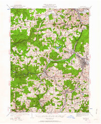
1922 Map of Du Bois
USGS Topo · Published 1962About this map
Sandy Lick Creek carves a central path through this section of the Pennsylvania plateau, serving as the industrial corridor for a dense network of early 20th-century railroads. The area around Du Bois and Falls Creek is a hub of transportation, where the Pennsylvania and Erie lines meet the Buffalo Rochester and Pittsburgh. This map illustrates the intersection of resource extraction and community growth, with mining settlements like Coal Glen, Beechtree, and Rathmel established along the hillsides.
Find a feature on this map
140 named features on this map. Tap any name to fly to it.
Don’t see what you’re looking for? This feature index may not catch every label — zoom into the map to look around manually.
Map Details
Editions of this 1922 Du Bois Map
2 editions found
Other maps of this area

1903 · Curwensville
USGS Topo · 1:62,500

1906 · Punxsutawney
USGS Topo · 1:62,500

1909 · Smicksburg
USGS Topo · 1:62,500

1918 · Loleta
USGS Topo · 1:62,500

1922 · Du Bois
USGS Topo · 1:62,500

1924 · Du Bois
USGS Topo · 1:62,500

1924 · Brookville
USGS Topo · 1:62,500

1926 · Brookville
USGS Topo · 1:62,500

1929 · Penfield
USGS Topo · 1:62,500

1932 · Penfield
USGS Topo · 1:62,500