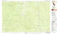
1981 Map of Dubakella Mtn
USGS Topo · Published 1981About this map
Trinity National Forest defines the high-country landscape of this 1981 survey, where the peaks of Plummer Peak and Dubakella Mtn overlook a complex network of resource management and rural life. The settlement of Wildwood serves as a local hub, complete with the Wildwood Sch and nearby Sewage Disposal Ponds, while the aptly named Peanut sits at a junction to the northwest. The map reveals the infrastructure of water and transport through the Blue Point Ditch and numerous 4WD trails that penetrate the deep drainages of Salt Creek and Hayfork Creek.
Find a feature on this map
67 named features on this map. Tap any name to fly to it.
Don’t see what you’re looking for? This feature index may not catch every label — zoom into the map to look around manually.
Map Details
Editions of this 1981 Dubakella Mtn Map
2 editions found
Other maps of this area

1890 · Red Bluff
USGS Topo · 1:250,000

1894 · Red Bluff
USGS Topo · 1:250,000

1909 · Big Bar
USGS Topo · 1:96,000

1913 · Weaverville
USGS Topo · 1:125,000

1915 · Big Bar and Vicinity
USGS Topo · 1:250,000

1918 · Anada
USGS Topo · 1:62,500

1931 · Hoaglin
USGS Topo · 1:96,000

1935 · Hoaglin
USGS Topo · 1:125,000

1950 · Weaverville
USGS Topo · 1:62,500

1951 · Hayfork
USGS Topo · 1:62,500