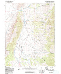
1981 Map of Duck Creek Valley
USGS Topo · Published 1994About this map
Pescio Ranch and the Berry Creek Grove anchor this pocket of the Nevada high country, where the Duck Creek Range meets the eastern reaches of the Humboldt National Forest. In this early 1980s survey, the landscape is defined by its water management and resource extraction, featuring the Duck Creek Dam and several irrigation infrastructures like the North Aqueduct. Prospectors once combed these slopes, leaving behind traces at the Brennen Mine and various prospects scattered through the gulches.
Find a feature on this map
36 named features on this map. Tap any name to fly to it.
Don’t see what you’re looking for? This feature index may not catch every label — zoom into the map to look around manually.
Map Details
Editions of this 1981 Duck Creek Valley Map
2 editions found
Other maps of this area

1952 · Ely
USGS Topo · 1:125,000

1956 · Ely
USGS Topo · 1:250,000

1958 · McGill
USGS Topo · 1:24,000

1958 · East Ely
USGS Topo · 1:24,000

1958 · McGill
USGS Topo · 1:62,500

1959 · Ely
USGS Topo · 1:250,000

1959 · Schell Peaks
USGS Topo · 1:62,500

1963 · Ely
USGS Topo · 1:250,000

1981 · North Schell Peak
USGS Topo · 1:24,000

1981 · Duck Creek Valley
USGS Topo · 1:24,000