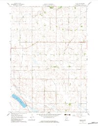
1962 Map of Dudley
USGS Topo · Published 1983About this map
Dudley sits at the intersection of rail and agriculture in this Lyon County landscape, where the Chicago and North Western railroad provides a straight East-West corridor through the prairie. The importance of water management to this farming region is evident in the engineered waterways like Judicial Ditch No 60, Judicial Ditch No 44, and Judicial Ditch No 31, which channel water across the townships of Fairview, Stanley, Lake Marshall, and Clifton. To the south, Lake Marshall and Meadow Creek offer more natural hydrological features, while the Redwood River flows along the northern edge of the survey. The presence of a Gravel Pit near the lake suggests the local extraction industries that supported road and rail maintenance during this era of rural development.
Find a feature on this map
13 named features on this map. Tap any name to fly to it.
Don’t see what you’re looking for? This feature index may not catch every label — zoom into the map to look around manually.
Map Details
Editions of this 1962 Dudley Map
2 editions found
Other maps of this area

1953 · New Ulm
USGS Topo · 1:250,000

1957 · New Ulm
USGS Topo · 1:250,000

1958 · New Ulm
USGS Topo · 1:250,000

1962 · Dudley
USGS Topo · 1:24,000

1962 · Cottonwood
USGS Topo · 1:24,000

1962 · School Grove Lake
USGS Topo · 1:24,000

1962 · Milroy SE
USGS Topo · 1:24,000

1962 · Amiret
USGS Topo · 1:24,000

1962 · Milroy
USGS Topo · 1:24,000

1963 · Marshall SE
USGS Topo · 1:24,000