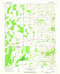
1962 Map of Dudley
USGS Topo · Published 1963About this map
Dudley serves as the central hub of this Stoddard County landscape, situated along the Missouri Pacific railroad line. The map reveals an area defined by extensive drainage management, with features like the Dudley Main Ditch, Cypress Lateral No 1, and Mule Ditch crisscrossing the terrain to manage water levels around The Glades Swamp. These engineering efforts transformed the wetlands into productive territory, though remnants of the original landscape persist in the bottomlands of Cane Creek and Lick Creek.
Find a feature on this map
32 named features on this map. Tap any name to fly to it.
Don’t see what you’re looking for? This feature index may not catch every label — zoom into the map to look around manually.
Map Details
Editions of this 1962 Dudley Map
2 editions found
Other maps of this area

1934 · Bloomfield
USGS Topo · 1:62,500

1934 · Puxico
USGS Topo · 1:62,500

1939 · Bloomfield
USGS Topo · 1:62,500

1939 · Puxico
USGS Topo · 1:62,500

1940 · Malden
USGS Topo · 1:62,500

1940 · Valley Ridge
USGS Topo · 1:62,500

1949 · Bloomfield
USGS Topo · 1:62,500

1956 · Valley Ridge
USGS Topo · 1:62,500

1956 · Malden
USGS Topo · 1:62,500

1956 · Dyersburg
USGS Topo · 1:250,000