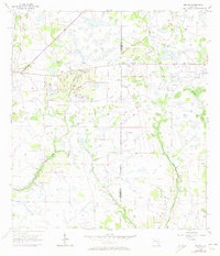
1956 Map of Duette
USGS Topo · Published 1973About this map
The small settlement of Duette sits at the junction of State Route 62 and State Route 675, serving as a rare focal point in this 1950s landscape of wetlands and drainage patterns. The map captures the remote character of the border between Manatee Co and Hardee Co, an area defined by the meandering headwaters of the region’s major water systems. The North Fork Manatee River and East Fork Manatee River branch through the western half of the quadrangle, while the eastern section is dominated by the winding path of Horse Creek and its tributary, West Fork Horse Creek. These watercourses reveal the natural topography of Florida's interior before significant modern development, showing the complex network of sloughs and marshes like those surrounding Brushy Creek. For local historians, the sheet provides an essential look at the rural road networks and surveying lines that established the early twentieth-century character of these counties.
Find a feature on this map
7 named features on this map. Tap any name to fly to it.
Don’t see what you’re looking for? This feature index may not catch every label — zoom into the map to look around manually.
Map Details
Editions of this 1956 Duette Map
5 editions found
Other maps of this area

1955 · Ft. Green
USGS Topo · 1:24,000

1955 · Baird
USGS Topo · 1:24,000

1956 · Ona
USGS Topo · 1:24,000

1956 · Myakka City NW
USGS Topo · 1:24,000

1956 · Ft Lonesome
USGS Topo · 1:24,000

1956 · Myakka Head
USGS Topo · 1:24,000

1956 · Duette NE
USGS Topo · 1:24,000

1956 · Duette
USGS Topo · 1:24,000

1956 · Keentown
USGS Topo · 1:24,000

1956 · Tampa
USGS Topo · 1:250,000