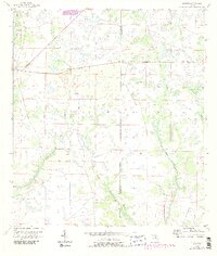
1956 Map of Duette
USGS Topo · Published 1987About this map
The small settlement of Duette serves as the primary focal point in this 1950s survey of eastern Manatee County. The landscape is defined by the headwaters of two significant river systems, where the drainage of the North Fork Manatee River and East Fork Manatee River meet the eastern watershed of the Horse Creek basin. The area exhibits a distinct lack of heavy development, instead showing a network of rural roads and section lines that cross between Manatee and Hardee counties. Revisions made in the mid-1980s illustrate subtle changes in land use, yet the region remains characterized by expansive woodland and the meandering paths of West Fork Horse Creek and Brushy Creek. This map captures a transition between the coastal development of western Florida and the interior agricultural lands of the central peninsula.
Find a feature on this map
7 named features on this map. Tap any name to fly to it.
Don’t see what you’re looking for? This feature index may not catch every label — zoom into the map to look around manually.
Map Details
Editions of this 1956 Duette Map
5 editions found
Other maps of this area

1955 · Ft. Green
USGS Topo · 1:24,000

1955 · Baird
USGS Topo · 1:24,000

1956 · Ona
USGS Topo · 1:24,000

1956 · Myakka City NW
USGS Topo · 1:24,000

1956 · Ft Lonesome
USGS Topo · 1:24,000

1956 · Myakka Head
USGS Topo · 1:24,000

1956 · Duette NE
USGS Topo · 1:24,000

1956 · Duette
USGS Topo · 1:24,000

1956 · Keentown
USGS Topo · 1:24,000

1956 · Tampa
USGS Topo · 1:250,000