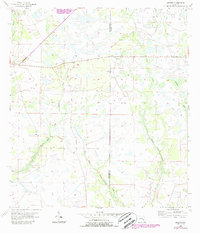
1956 Map of Duette
USGS Topo · Published 1987About this map
The small settlement of Duette serves as the primary landmark in this rural Florida landscape, situated where the North Fork Manatee River begins to wind through the western terrain. This 1956 survey, later updated with 1980s aerial data, reveals a region defined by its complex drainage network and low-lying wetlands. The eastern half of the map is dominated by the southward flow of Horse Creek and its tributary, West Fork Horse Creek, which carve through the plains near the Manatee Co Hardee Co line. State Road 62 provides the principal east-west transit through this agricultural and ranching country. The presence of numerous swamps and the branching headwaters of the East Fork Manatee River suggest a landscape that remained largely undeveloped, dominated by natural watercourses and small-scale land improvements well into the late twentieth century.
Find a feature on this map
8 named features on this map. Tap any name to fly to it.
Don’t see what you’re looking for? This feature index may not catch every label — zoom into the map to look around manually.
Map Details
Editions of this 1956 Duette Map
5 editions found
Other maps of this area

1955 · Ft. Green
USGS Topo · 1:24,000

1955 · Baird
USGS Topo · 1:24,000

1956 · Ona
USGS Topo · 1:24,000

1956 · Myakka City NW
USGS Topo · 1:24,000

1956 · Ft Lonesome
USGS Topo · 1:24,000

1956 · Myakka Head
USGS Topo · 1:24,000

1956 · Duette NE
USGS Topo · 1:24,000

1956 · Duette
USGS Topo · 1:24,000

1956 · Keentown
USGS Topo · 1:24,000

1956 · Tampa
USGS Topo · 1:250,000