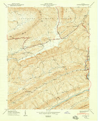
1950 Map of Duffield
USGS Topo · Published 1950About this map
Purchase Ridge and the Big Knobs dominate this 1950 topography of Scott and Lee Counties, where the Southern RR winds through steep mountain gaps. The river-and-rail corridor is defined by the Clinch River and the North Fork Clinch River, supporting small communities like Duffield, Clinchport, and Pattonsville. The historic Daniel Boone Boundary Trail cuts across Pine Ridge, tracing a path near Kane Gap and the northern reaches of the Jefferson National Forest. For genealogists, the map is remarkably dense with family-named landmarks and resting places, including the Lawson Cem, Horton Cem, and Willis Campbell Cem. Transportation infrastructure of the mid-century is well-preserved here, from the Bald Knob Tunnel and Copper Siding to the river crossing at Powers Ford, illustrating a landscape shaped by both the rugged geology and the needs of the rural Southwest Virginia economy.
Find a feature on this map
112 named features on this map. Tap any name to fly to it.
Don’t see what you’re looking for? This feature index may not catch every label — zoom into the map to look around manually.
Map Details
Editions of this 1950 Duffield Map
2 editions found
Other maps of this area

1894 · Estillville
USGS Topo · 1:125,000

1920 · Wise
USGS Topo · 1:48,000

1921 · Big Stone Gap
USGS Topo · 1:48,000

1921 · Wise
USGS Topo · 1:62,500

1922 · Big Stone Gap
USGS Topo · 1:62,500

1929 · Big Stone Gap
USGS Topo · 1:62,500

1935 · Moggasin
USGS Topo · 1:48,000

1935 · Looneys Gap
USGS Topo · 1:24,000

1935 · East Stone Gap
USGS Topo · 1:24,000
1935 · Keokee
USGS Topo · 1:24,000