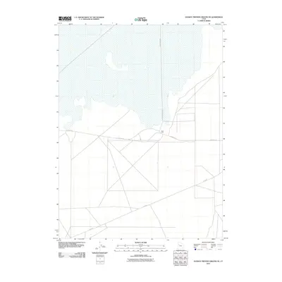
2010 Map of Dugway Proving Ground NE
USGS Topo · Published 2010About this map
Baker Area sits at the junction of several military access routes in this sparsely labeled section of the Great Salt Lake Desert. The 2010 landscape is dominated by a grid of specialized corridors including Goodyear Rd and Stark Rd, reflecting the highly structured environment of a modern testing range. Unlike typical rural quadrangles, this area lacks civilian infrastructure, emphasizing its dedicated military purpose. A prominent feature is the north-south transit of N Wig Mountain Rd, which skirts the edge of the expansive salt flats to the north. The map effectively illustrates the intersection of vast natural alkali flats with the precise, geometric layout required for experimental operations.
Find a feature on this map
4 named features on this map. Tap any name to fly to it.
Don’t see what you’re looking for? This feature index may not catch every label — zoom into the map to look around manually.
Map Details
Editions of this 2010 Dugway Proving Ground NE Map
This is the sole edition of this map. No revisions or reprints were ever made.
Other maps of this area

1885 · Tooele Valley
USGS Topo · 1:250,000

1953 · Tooele
USGS Topo · 1:250,000

1954 · Wig Mtn SW
USGS Topo · 1:24,000

1954 · Dugway Proving Ground SE
USGS Topo · 1:24,000

1954 · Dugway Proving Ground NE
USGS Topo · 1:24,000

1954 · Dugway Proving Ground SW
USGS Topo · 1:24,000

1954 · Camels Back Ridge NW
USGS Topo · 1:24,000

1954 · Dugway Proving Ground NW
USGS Topo · 1:24,000

1955 · Camels Back Ridge SW
USGS Topo · 1:24,000

1955 · Wig Mtn
USGS Topo · 1:24,000