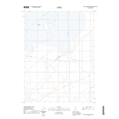
2023 Map of Dugway Proving Ground NE
USGS Topo · Published 2023About this map
The Great Salt Lake Desert dominates this Tooele County landscape, presenting a stark expanse of salt flats and arid terrain. This specialized military environment contains the West Desert Test Center, a site defined by its isolation and geometric road network. Infrastructure is strictly utilitarian, primarily consisting of remote corridors such as Goodyear Rd and N Wig Mountain Rd that facilitate movement across the basin. The map reveals the intricate surveying of the proving ground, where desert tracks like Stark Rd and Peter Charlie Rd intersect at precise intervals. This modern survey reflects the ongoing strategic use of Utah's salt deserts for defense testing, illustrating how the remote landscape has been adapted for high-tech research and secure operations.
Find a feature on this map
6 named features on this map. Tap any name to fly to it.
Don’t see what you’re looking for? This feature index may not catch every label — zoom into the map to look around manually.
Map Details
Editions of this 2023 Dugway Proving Ground NE Map
This is the sole edition of this map. No revisions or reprints were ever made.
Other maps of this area

1885 · Tooele Valley
USGS Topo · 1:250,000

1953 · Tooele
USGS Topo · 1:250,000

1954 · Wig Mtn SW
USGS Topo · 1:24,000

1954 · Dugway Proving Ground SE
USGS Topo · 1:24,000

1954 · Dugway Proving Ground NE
USGS Topo · 1:24,000

1954 · Dugway Proving Ground SW
USGS Topo · 1:24,000

1954 · Camels Back Ridge NW
USGS Topo · 1:24,000

1954 · Dugway Proving Ground NW
USGS Topo · 1:24,000

1955 · Camels Back Ridge SW
USGS Topo · 1:24,000

1955 · Wig Mtn
USGS Topo · 1:24,000