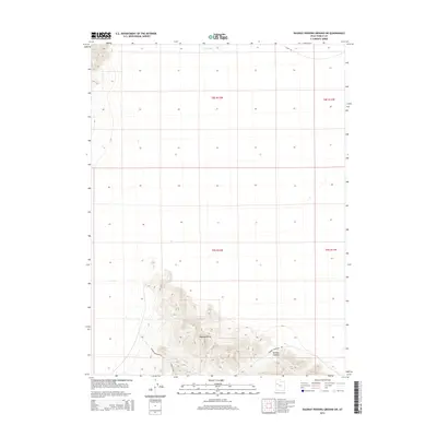
2014 Map of Dugway Proving Ground SW
USGS Topo · Published 2014About this map
The Dugway Range dominates the southern reaches of this Tooele County map, showing the topographical relief of this high-desert mountain chain. The intricate contours trace the steep elevations of Bullion Canyon, a prominent geological feature situated in the southeast corner of the quadrangle. In the north, the landscape flattens into the expansive basin of the Great Salt Lake Desert, where Dry Lake sits as a significant seasonal drainage feature. The area's relative isolation within a government reservation is marked by a sparse network of roads, including Stark Rd and Dugway Mountain Rd. A distinctive landmark known as Kellys Hole provides a specific point of interest for those studying the rugged interior geography of the range. The map provides a detailed look at the Public Land Survey System divisions, delineating townships such as t8s r12w and t9s r11w across the desert floor.
Find a feature on this map
10 named features on this map. Tap any name to fly to it.
Don’t see what you’re looking for? This feature index may not catch every label — zoom into the map to look around manually.
Map Details
Editions of this 2014 Dugway Proving Ground SW Map
This is the sole edition of this map. No revisions or reprints were ever made.
Other maps of this area

1908 · Fish Springs
USGS Topo · 1:250,000

1910 · Fish Springs
USGS Topo · 1:250,000

1953 · Dugway Range NE
USGS Topo · 1:24,000

1953 · Dugway Range
USGS Topo · 1:62,500

1953 · Dugway Range NW
USGS Topo · 1:24,000

1953 · Tooele
USGS Topo · 1:250,000

1953 · Delta
USGS Topo · 1:250,000

1954 · Dugway Proving Ground SE
USGS Topo · 1:24,000

1954 · Dugway Proving Ground NE
USGS Topo · 1:24,000

1954 · Granite Peak
USGS Topo · 1:24,000