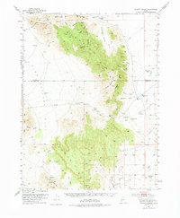
1953 Map of Dugway Range
USGS Topo · Published 1975About this map
The Pony Express Route cuts across this high desert landscape, passing through Simpson Springs and the Dugway Pony Express Sta as it skirts the southern edge of the Dugway Valley. This mid-century survey captures a region defined by isolation and mineral exploration, notably at Spor Mountain where a cluster of claims including the Lost Sheep Mine, Blowout Mine, and Thursday Mine are recorded. The steep topography of the Dugway Range dominates the center of the sheet, providing a natural barrier between Fish Springs Flat to the west and the expansive Dugway Proving Ground Bombing and Gunnery Range to the north. Water sources are scarce but critical, marked by isolated points like Wildhorse Spr and the Dugway Topaz Well, reflecting the harsh environmental constraints on travel and industry in the West Desert.
Find a feature on this map
46 named features on this map. Tap any name to fly to it.
Don’t see what you’re looking for? This feature index may not catch every label — zoom into the map to look around manually.
Map Details
Editions of this 1953 Dugway Range Map
3 editions found
Other maps of this area

1885 · Sevier Desert
USGS Topo · 1:250,000

1885 · Tooele Valley
USGS Topo · 1:250,000

1908 · Fish Springs
USGS Topo · 1:250,000

1910 · Fish Springs
USGS Topo · 1:250,000

1953 · Dugway Range NE
USGS Topo · 1:24,000

1953 · Dugway Pass
USGS Topo · 1:24,000

1953 · Dugway Range
USGS Topo · 1:62,500

1953 · Topaz Mtn
USGS Topo · 1:62,500

1953 · Dugway Range NW
USGS Topo · 1:24,000

1953 · Tooele
USGS Topo · 1:250,000