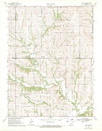
1969 Map of Duluth
USGS Topo · Published 1971About this map
Duluth and the surrounding townships in Pottawatomie and Nemaha Counties are defined by a complex network of prairie streams and early transport corridors. The Union Pacific railroad cuts through the southern landscape, following the valley of Hise Creek and Mill Creek near the settlement of Duluth. This area showcases the transition from upland prairie to wooded creek bottoms, with numerous named waterways like French Creek, Mulberry Creek, and Mud Creek carving into the terrain. Genealogy researchers can locate several key community landmarks, including St Patricks Ch and its associated St Patricks Cem in the northeast, as well as the Onaga Cemetery, Home Cem, and Ragar Cem. The mapping of small locales like Neuchatel and Beckerville provides a detailed view of Kansas rural life before modern consolidation shifted the local population centers.
Find a feature on this map
25 named features on this map. Tap any name to fly to it.
Don’t see what you’re looking for? This feature index may not catch every label — zoom into the map to look around manually.
Map Details
Editions of this 1969 Duluth Map
This is the sole edition of this map. No revisions or reprints were ever made.
Other maps of this area

1889 · Seneca
USGS Topo · 1:125,000

1889 · Wamego
USGS Topo · 1:125,000

1894 · Seneca
USGS Topo · 1:125,000

1894 · Wamego
USGS Topo · 1:125,000

1955 · Manhattan
USGS Topo · 1:250,000

1956 · Manhattan
USGS Topo · 1:250,000

1957 · Manhattan
USGS Topo · 1:250,000
1964 · Onaga NE
USGS Topo · 1:24,000
1964 · Onaga
USGS Topo · 1:24,000
1964 · Westmoreland NE
USGS Topo · 1:24,000