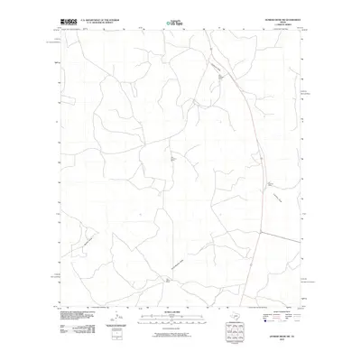
2010 Map of Dunbar Draw SW
USGS Topo · Published 2010About this map
The vast ranchlands of Val Verde County define this portion of West Texas, where water and property ownership are the primary markers of the landscape. Named draws, including the prominent Cauthorn Draw, Buckley Draw, and South Buckley Draw, snake through the terrain, serving as the essential drainage system for this semi-arid region. These geographic features often dictate the placement of local infrastructure and historic homesteads. Family-held lands are central to the area's identity, with established operations such as the Mack Cauthorn Ranch, Dan Cauthorn Ranch, J A Cauthorn Ranch, and Sam Allison Ranch anchoring the local geography. This survey provides a precise look at the ranch boundaries and topographical shifts that have shaped the rural economy of the Edwards Plateau well into the 21st century.
Find a feature on this map
7 named features on this map. Tap any name to fly to it.
Don’t see what you’re looking for? This feature index may not catch every label — zoom into the map to look around manually.
Map Details
Editions of this 2010 Dunbar Draw SW Map
This is the sole edition of this map. No revisions or reprints were ever made.
Other maps of this area

1954 · Sonora
USGS Topo · 1:250,000

1958 · Sonora
USGS Topo · 1:250,000

1967 · Dunbar Draw SW
USGS Topo · 1:24,000

1967 · Flat Rock Draw SE
USGS Topo · 1:24,000

1967 · Dunbar Draw NW
USGS Topo · 1:24,000

1967 · Dunbar Draw NE
USGS Topo · 1:24,000

1967 · Hudspeth Draw
USGS Topo · 1:24,000

1967 · Dunbar Draw SE
USGS Topo · 1:24,000
1971 · Turney Draw NE
USGS Topo · 1:24,000

1973 · Turney Draw NW
USGS Topo · 1:24,000