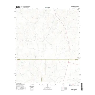
2016 Map of Dunbar Draw SW
USGS Topo · Published 2016About this map
The high divide of the Edwards Plateau marks the convergence of three Texas counties on this 2016 survey. This arid landscape is defined by a network of drainage features, including the prominent Buckley Draw and its southern branch, South Buckley Draw. The presence of Buckley Tank suggests the importance of water management in this sparsely populated ranching country. Transportation is dominated by the winding path of the Juno Hwy, which traverses the high ground between the draws. In the northeast corner, the terrain falls away toward Cusenbury Draw, while the southeast is marked by the headwaters of Cauthorn Draw. This map provides a detailed view of the complex topography and limited road network, including Pvt Rd 4430, at the intersection of Sutton, Val Verde, and Edwards counties.
Find a feature on this map
10 named features on this map. Tap any name to fly to it.
Don’t see what you’re looking for? This feature index may not catch every label — zoom into the map to look around manually.
Map Details
Editions of this 2016 Dunbar Draw SW Map
This is the sole edition of this map. No revisions or reprints were ever made.
Other maps of this area

1954 · Sonora
USGS Topo · 1:250,000

1958 · Sonora
USGS Topo · 1:250,000

1967 · Dunbar Draw SW
USGS Topo · 1:24,000

1967 · Flat Rock Draw SE
USGS Topo · 1:24,000

1967 · Dunbar Draw NW
USGS Topo · 1:24,000

1967 · Dunbar Draw NE
USGS Topo · 1:24,000

1967 · Hudspeth Draw
USGS Topo · 1:24,000

1967 · Dunbar Draw SE
USGS Topo · 1:24,000
1971 · Turney Draw NE
USGS Topo · 1:24,000

1973 · Turney Draw NW
USGS Topo · 1:24,000