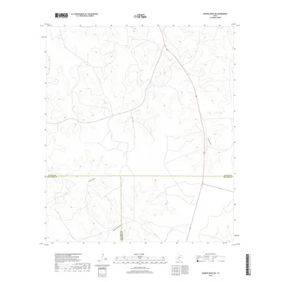
2019 Map of Dunbar Draw SW
USGS Topo · Published 2019About this map
The convergence of Val Verde, Edwards, and Sutton counties takes place across this high-plains landscape, characterized by a series of intermittent drainages that define the local topography. This 2019 survey documents the sparsely populated borderland where Buckley Draw and South Buckley Draw carve through the limestone terrain. The only significant transportation infrastructure is U.S. Route 277, which cuts vertically through the eastern portion of the sheet. Aside from Pvt Rd 4430, the interior remains largely inaccessible to public thoroughfares, reflecting the remote ranching nature of the Edwards Plateau. These seasonal watercourses, including Cauthorn Draw, are the primary landmarks in an area defined more by its jurisdictional boundaries than by concentrated settlement.
Find a feature on this map
8 named features on this map. Tap any name to fly to it.
Don’t see what you’re looking for? This feature index may not catch every label — zoom into the map to look around manually.
Map Details
Editions of this 2019 Dunbar Draw SW Map
This is the sole edition of this map. No revisions or reprints were ever made.
Other maps of this area

1954 · Sonora
USGS Topo · 1:250,000

1958 · Sonora
USGS Topo · 1:250,000

1967 · Dunbar Draw SW
USGS Topo · 1:24,000

1967 · Flat Rock Draw SE
USGS Topo · 1:24,000

1967 · Dunbar Draw NW
USGS Topo · 1:24,000

1967 · Dunbar Draw NE
USGS Topo · 1:24,000

1967 · Hudspeth Draw
USGS Topo · 1:24,000

1967 · Dunbar Draw SE
USGS Topo · 1:24,000
1971 · Turney Draw NE
USGS Topo · 1:24,000

1973 · Turney Draw NW
USGS Topo · 1:24,000