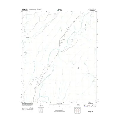
2012 Map of Dunbar
USGS Topo · Published 2012About this map
The Kiamichi River winds through this section of Pushmataha County, defining a landscape of high ridges and narrow valleys where the settlements of Dunbar, Eubanks, and Wadena are situated. The terrain is marked by prominent elevations including Bull Creek Mtn, Big Mtn, and Box Spring Mtn, which frame the lowlands of Johns Valley and Blowout Hollow. Road networks such as Dunbar Loop and Lost Mountain Rd provide access to these rural communities and the family history preserved at Reynolds Cem. Numerous tributaries, including Wildcat Cr, Long Bell Cr, and Grassy Cr, feed into the river system, illustrating the complex drainage of the Ouachita region. This 2012 survey documents the persistent rural character of the area, showing how local infrastructure follows the natural contours of the mountains and river bends.
Find a feature on this map
47 named features on this map. Tap any name to fly to it.
Don’t see what you’re looking for? This feature index may not catch every label — zoom into the map to look around manually.
Map Details
Editions of this 2012 Dunbar Map
This is the sole edition of this map. No revisions or reprints were ever made.
Other maps of this area

1898 · McAlester
USGS Topo · 1:125,000

1901 · Antlers
USGS Topo · 1:125,000

1901 · Tuskahoma
USGS Topo · 1:125,000

1901 · Alikchi
USGS Topo · 1:125,000

1908 · Tuskahoma
USGS Topo · 1:125,000

1909 · Mc Alester
USGS Topo · 1:125,000

1909 · Tuskahoma
USGS Topo · 1:125,000

1912 · Antlers
USGS Topo · 1:125,000

1925 · Antlers
USGS Topo · 1:125,000

1950 · Mcalester
USGS Topo · 1:250,000