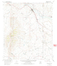
1960 Map of Duncan
USGS Topo · Published 1983About this map
Duncan and Franklin anchor the agricultural and transport corridor of the Gila River valley in this 1960 field-checked survey. The Southern Pacific Railroad parallels the river, supporting a local economy evidenced by a Cotton Gin and a nearby Gaging Sta. The terrain transitions sharply from the irrigated river bottom to the high peaks of the Peloncillo Mountains, where Whitlock Peak stands as a prominent landmark. To the west, the arid Whitlock Valley contains scattered water sources like Hot Well, while the eastern portion of the map crosses the border into New Mexico to include Virden. This area is characterized by a sophisticated system of small water management features, including Horseshoe Terrace Dam and various reservoirs in Dagger Draw, reflecting the essential nature of water rights and ranching infrastructure in the high desert.
Find a feature on this map
68 named features on this map. Tap any name to fly to it.
Don’t see what you’re looking for? This feature index may not catch every label — zoom into the map to look around manually.
Map Details
Editions of this 1960 Duncan Map
4 editions found

Other maps of this area

1917 · San Simon
USGS Topo · 1:125,000

1926 · Orange Butte
USGS Topo · 1:62,500

1928 · Bowie
USGS Topo · 1:62,500

1949 · Bowie
USGS Topo · 1:62,500

1950 · San Simon
USGS Topo · 1:62,500

1950 · Bowie
USGS Topo · 1:62,500

1951 · San Simon
USGS Topo · 1:62,500

1954 · Silver City
USGS Topo · 1:250,000

1958 · Silver City
USGS Topo · 1:250,000

1959 · Steeple Rock
USGS Topo · 1:62,500