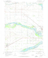
1958 Map of Duncan
USGS Topo · Published 1974About this map
The Loup River and Platte River converge in this mid-century portrait of Platte County, defining a landscape of braided channels and fertile bottomlands. The Union Pacific corridor serves as the primary axis for development, linking the western settlement of Duncan to the outskirts of Columbus in the east. The map captures an era of rural education before widespread school consolidation, evidenced by the distribution of several one-room schoolhouses such as School No 16 and School No 3 across the township grid. Water management is a central theme of the geography, with the Canal and Babcock Lake to the north, and Wagners Lake situated near the river forks. Local history and genealogy are anchored by features like Jackson Cem and the small siding of Sheldonville, providing a specific look at the agricultural and transport infrastructure that shaped this river-valley community.
Find a feature on this map
27 named features on this map. Tap any name to fly to it.
Don’t see what you’re looking for? This feature index may not catch every label — zoom into the map to look around manually.
Map Details
Editions of this 1958 Duncan Map
3 editions found
Other maps of this area

1896 · Stromsburg
USGS Topo · 1:125,000

1899 · David City
USGS Topo · 1:125,000

1955 · Fremont
USGS Topo · 1:250,000

1957 · Fremont
USGS Topo · 1:250,000

1958 · Fremont
USGS Topo · 1:250,000

1958 · Monroe
USGS Topo · 1:24,000

1958 · Duncan
USGS Topo · 1:24,000

1958 · Columbus SW
USGS Topo · 1:24,000

1958 · Silver Creek SE
USGS Topo · 1:24,000

1958 · Columbus SE
USGS Topo · 1:24,000