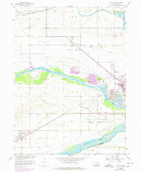
1958 Map of Duncan
USGS Topo · Published 1977About this map
Duncan and the western edge of Columbus define the landscape of this 1958 survey, where the confluence of the Loup River and Platte River shapes the local geography. The area is characterized by a dense network of water management features, including a large Canal and Lake Babcock, supporting the agricultural needs of the valley. The Union Pacific railroad runs diagonally across the terrain, passing through the small community of Sheldonville and serving as a primary transportation artery through Butler and Oconee townships.
Find a feature on this map
28 named features on this map. Tap any name to fly to it.
Don’t see what you’re looking for? This feature index may not catch every label — zoom into the map to look around manually.
Map Details
Editions of this 1958 Duncan Map
3 editions found
Other maps of this area

1896 · Stromsburg
USGS Topo · 1:125,000

1899 · David City
USGS Topo · 1:125,000

1955 · Fremont
USGS Topo · 1:250,000

1957 · Fremont
USGS Topo · 1:250,000

1958 · Fremont
USGS Topo · 1:250,000

1958 · Monroe
USGS Topo · 1:24,000

1958 · Duncan
USGS Topo · 1:24,000

1958 · Columbus SW
USGS Topo · 1:24,000

1958 · Silver Creek SE
USGS Topo · 1:24,000

1958 · Columbus SE
USGS Topo · 1:24,000