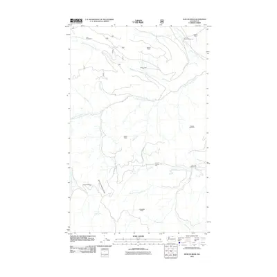
2011 Map of Duncan Ridge
USGS Topo · Published 2011About this map
Duncan Ridge and the surrounding high country of Okanogan County are defined by a network of drainage systems feeding into the Middle Fork Toats Coulee Creek. This 2011 survey documents a landscape focused on seasonal land use and forest management, highlighted by isolated structures like the Duncan James Cabin and the evocatively named Skull and Crossbones Cabin. The presence of the Cecil Creek Loading Corral and campgrounds such as Daisy Campground and North Fork Ninemile Campground suggests a dual reliance on livestock grazing and recreational access via the primitive Toats Coulee Rd. Terrain features like Skull and Crossbones Ridge, Tillman Mountain, and Finney Flat provide specific navigation points for land historians and surveyors tracking the historical footprints of forest cabins and backcountry infrastructure in this part of Washington.
Find a feature on this map
32 named features on this map. Tap any name to fly to it.
Don’t see what you’re looking for? This feature index may not catch every label — zoom into the map to look around manually.
Map Details
Editions of this 2011 Duncan Ridge Map
This is the sole edition of this map. No revisions or reprints were ever made.
Other maps of this area

1906 · Chopaka
USGS Topo · 1:125,000

1954 · Okanogan
USGS Topo · 1:250,000

1956 · Loomis
USGS Topo · 1:62,500

1956 · Tiffany Mountain
USGS Topo · 1:62,500

1956 · Horseshoe Basin
USGS Topo · 1:62,500

1957 · Conconully
USGS Topo · 1:62,500

1958 · Okanogan
USGS Topo · 1:250,000
1980 · Blue Goat Mtn
USGS Topo · 1:24,000
1981 · Corral Butte
USGS Topo · 1:24,000
1981 · Horseshoe Basin
USGS Topo · 1:24,000