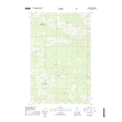
2020 Map of Duncan Ridge
USGS Topo · Published 2020About this map
Okanogan National Forest covers this high-altitude landscape in northern Washington, where a network of drainage systems and prominent ridgelines defines the terrain. The hydrology of the area is centered on the various forks of Middle Fork Toats Coulee Cr, which are fed by numerous tributaries including Patsy Cr and Cold Cr. Topographic landmarks like Duncan Ridge and the unusually named Skull and Crossbones Ridge suggest a region shaped by complex geological uplift and erosion, providing significant relief across the quadrangle.
Find a feature on this map
29 named features on this map. Tap any name to fly to it.
Don’t see what you’re looking for? This feature index may not catch every label — zoom into the map to look around manually.
Map Details
Editions of this 2020 Duncan Ridge Map
This is the sole edition of this map. No revisions or reprints were ever made.
Other maps of this area

1906 · Chopaka
USGS Topo · 1:125,000

1954 · Okanogan
USGS Topo · 1:250,000

1956 · Loomis
USGS Topo · 1:62,500

1956 · Tiffany Mountain
USGS Topo · 1:62,500

1956 · Horseshoe Basin
USGS Topo · 1:62,500

1957 · Conconully
USGS Topo · 1:62,500

1958 · Okanogan
USGS Topo · 1:250,000
1980 · Blue Goat Mtn
USGS Topo · 1:24,000
1981 · Corral Butte
USGS Topo · 1:24,000
1981 · Horseshoe Basin
USGS Topo · 1:24,000