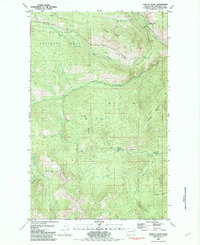
1981 Map of Duncan Ridge
USGS Topo · Published 1982About this map
The Okanogan National Forest dominates this highland landscape, captured here through aerial photography and field checks in the mid-1970s. The terrain is defined by a series of prominent ridges and drainage basins, most notably Duncan Ridge and the complex waterway system of Toats Coulee Creek. Evidence of backcountry habitation and high-country operations appears in the form of isolated structures such as James Cabin and the evocatively named Skull and Crossbones Cabin, while the Cecil Loading Corral near Cecil Creek points to the area's history of livestock management or timber transport.
Find a feature on this map
36 named features on this map. Tap any name to fly to it.
Don’t see what you’re looking for? This feature index may not catch every label — zoom into the map to look around manually.
Map Details
Editions of this 1981 Duncan Ridge Map
This is the sole edition of this map. No revisions or reprints were ever made.
Other maps of this area

1906 · Chopaka
USGS Topo · 1:125,000

1954 · Okanogan
USGS Topo · 1:250,000

1956 · Loomis
USGS Topo · 1:62,500

1956 · Tiffany Mountain
USGS Topo · 1:62,500

1956 · Horseshoe Basin
USGS Topo · 1:62,500

1957 · Conconully
USGS Topo · 1:62,500

1958 · Okanogan
USGS Topo · 1:250,000
1980 · Blue Goat Mtn
USGS Topo · 1:24,000
1981 · Corral Butte
USGS Topo · 1:24,000
1981 · Horseshoe Basin
USGS Topo · 1:24,000