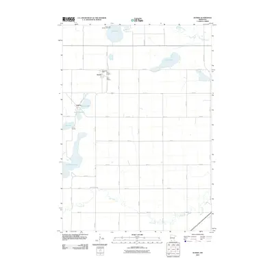
2010 Map of Dundee
USGS Topo · Published 2010About this map
Dundee and Kinbrae center this agricultural landscape in Nobles County, where a network of section-line roads like County Hwy-1 and County Hwy-7 connect small-town life to the surrounding prairie. The settlement at Dundee is marked by the Dundee Post Office and two nearby burial grounds, First Lutheran Cemetery and Saint Marys Cemetery, providing a concentrated point of interest for local genealogy. To the southwest, the smaller settlement of Kinbrae sits near the waters of Kinbrae Lake and Kinbrae Slough, with its own Kinbrae Cemetery located just outside the main cluster of homes.
Find a feature on this map
43 named features on this map. Tap any name to fly to it.
Don’t see what you’re looking for? This feature index may not catch every label — zoom into the map to look around manually.
Map Details
Editions of this 2010 Dundee Map
This is the sole edition of this map. No revisions or reprints were ever made.
Other maps of this area

1954 · Fairmont
USGS Topo · 1:250,000

1958 · Fairmont
USGS Topo · 1:250,000

1960 · Brewster
USGS Topo · 1:24,000

1960 · Okabena
USGS Topo · 1:24,000

1960 · Worthington North
USGS Topo · 1:24,000

1970 · Heron Lake NW
USGS Topo · 1:24,000

1970 · Dundee
USGS Topo · 1:24,000
1970 · Heron Lake NE
USGS Topo · 1:24,000

1970 · Fulda
USGS Topo · 1:24,000
1970 · Lime Creek
USGS Topo · 1:24,000